Yellow Breeches Creek
Yellow Breeches Water levels
Water Level Data available here.
Flooding information: The action level is 6 feet. The flood stage is 7 feet.
Minimum Water Levels: Per the brochure .. the USGS gauge height near Camp Hill
should read at least 1.4 feet to navigate the stream successfully. However .. we have
navigated it with Kayaks when it was at only 1.07 feet. The trips were from Spangler’s Mill
(B8) to New Cumberland Borough Park (B10) and from Lower Allen Community Park (B4)
to United Water PA Inc. ( B7).
Trip info at 1.07 feet water level...
The first trip (B8-B10) required minimal paddling ..had a few fast spots ..some bottom
scrapes.. and took 2 hours. The second trip (B4 to B7) required more paddling .. had
more bottom scrapes and took a little less than 2 hours
Trip info at 1.03 feet water level...
Traveled from Simpson Park (B2) to Lower Allen Community Park (B4) .. no carries .. some 'rapids'.
Took only 1.5 hours but we were paddling more because it was an evening trip
See Map for B Section below along with GPS Coordinates
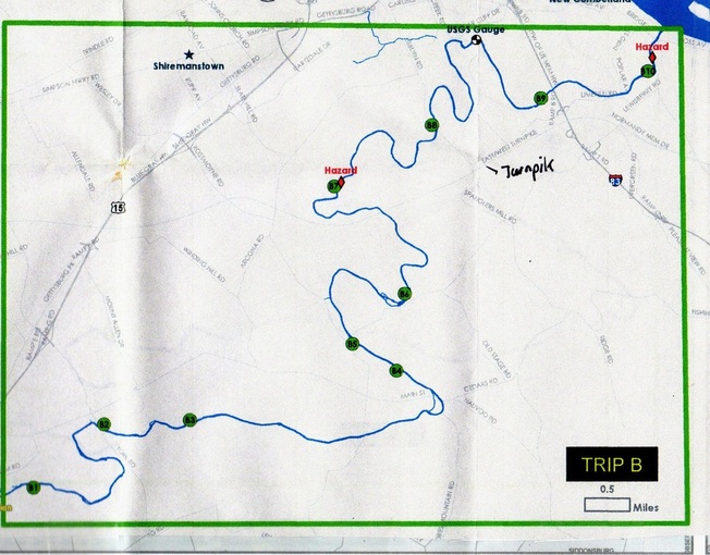
Access Points ... Mileage to next access point Coordinates
B1 Messiah College 2.5 40.154706,-76.99012
B2 Simpson Park 1.1 40.164576,-76.975579
B3 McCormick Park 3.6 40.165067,-76.957636
B4 Lower Allen Community Park 0.5 40.172466,-76.914861
B5 Liberty Forge 1.9 40.176809,-76.924002
B6 Yellow Breeches Park 2.8 40.184621,-76.913048
B7 United Water Pennsylvania, Inc. 2.2 40.201712,-76.927511
B8 Spangler’s Mill 3.6 40.211256,-76.907236
B9 Creekwood Park 1.5 40.215305,-76.884684
B10 New Cumberland Borough Park & Dam Take-out only 40.219395,-76.862528
