Shawnee State Park
Quick information..
Directions .... 1 hour 49 minutes from New Cumberland
Park website
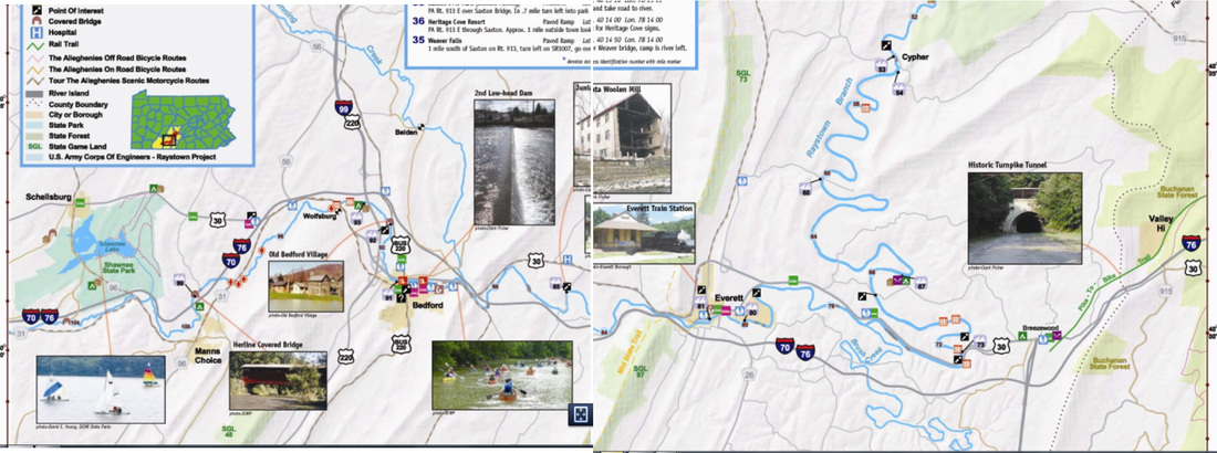
Shawnee State Park is 3,983 acres of Pennsylvania’s scenic Ridge and Valley Province. Ten miles west of the historic town of Bedford along US 30, Shawnee has modern recreational facilities that blend into the natural environment. A focal point of the park is the 451-acre Shawnee Lake.
Park Map
Camping Brochure
Rec Guide
-------------------------------------------------------------------------------
Water Trails
Juniata Raystown Branch
Directions: 14 minutes
This one starts near Shawnee and continues to Bedford and beyond. For full brochure click here.
Directions .... 1 hour 49 minutes from New Cumberland
Park website
Shawnee State Park is 3,983 acres of Pennsylvania’s scenic Ridge and Valley Province. Ten miles west of the historic town of Bedford along US 30, Shawnee has modern recreational facilities that blend into the natural environment. A focal point of the park is the 451-acre Shawnee Lake.
Park Map
Camping Brochure
Rec Guide
-------------------------------------------------------------------------------
Water Trails
Juniata Raystown Branch
Directions: 14 minutes
This one starts near Shawnee and continues to Bedford and beyond. For full brochure click here.
Juniata Upper Branch
Directions 1 hour
Brochure for Upper Juniata Water Trail
------------------------------------------
Rails to Trails ...
Good Map of trails in area
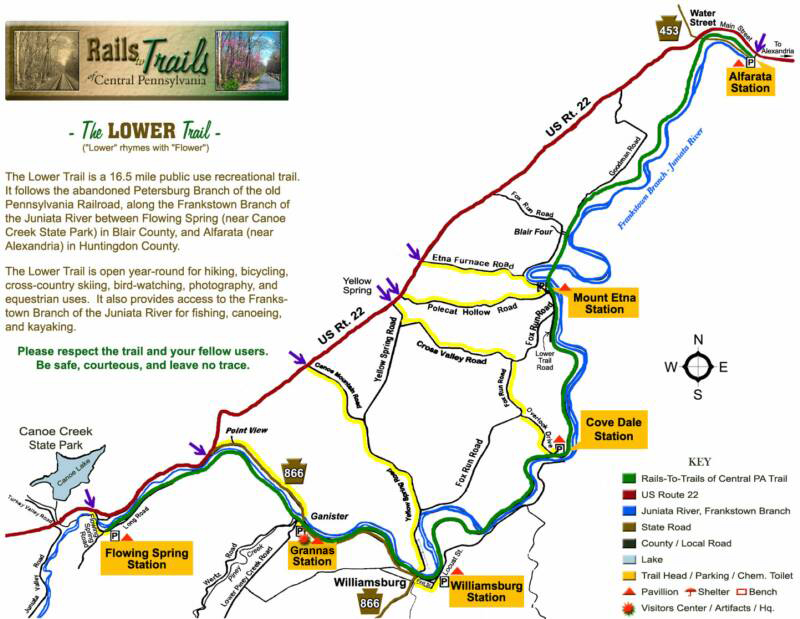
Lower Trail
Directions: Takes 51 minutes
Distinctive Features
When traveling along the trail, either by foot or bike, you can see many remnants of the canal era, including remains of locks and foundations of lock tenders' houses, as well as the historical Mt. Etna iron plantation area. There are a number of bridge crossings of the Juniata River and one covered bridge over the tail race of a historic mill stream. Remains of tipples and massive concrete rock crushers from abandoned stone quarries along the trail hint of the once industrial nature of the now-unbroken forest beside the river.
The trail supports many different plant and animal species and the Audubon Society has identified portions of the Lower Trail as “Important Birding Areas.” A number of Bald Eagles and Osprey have been spotted along the trail. There are also many beautiful and some rare plant species along the trail. The Lower Trail is part of the Mid State Trail and the Pittsburgh-to-Harrisburg Main Line Canal Greenway and has been designated a National Recreation Trail by the National Park Service. It is a beautiful, very family-friendly rural trail through wooded areas with few road crossings and provides access to the adjacent Juniata River Water Trail.
- Length: 16.5 miles in length
- Trail surface(s): 85% crushed rolled limestone, 15% paved
- Trailheads: Trailheads are called "Stations" because when the railroad ran, there were station stops there
Lower Trail Map
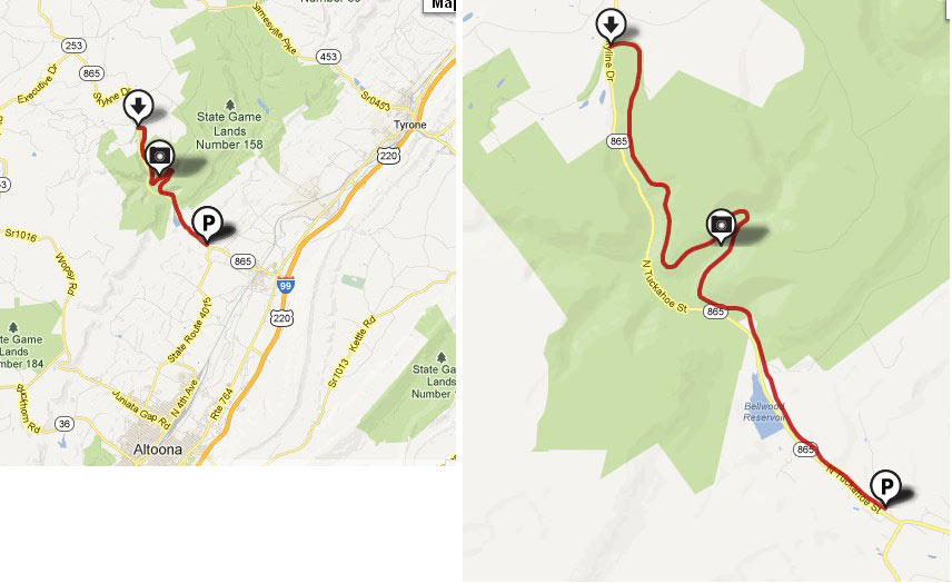
The Bells Gap Railroad was introduced as a narrow gauge spur line in the 1850’s with the intention of connecting the Pennsylvania Railroad Mainline to the people and resources in the northern portions of Pennsylvania. It would move people and goods northwest and would help the coal and lumber industry to the west move their goods to the cities along the Mainline and beyond.
The spur line connected to the Mainline in the center of Bellwood, near where the Bellwood-Antis Community Park is now located. Eventually, the spur would be converted to a standard gauge line in 1872, allowing easy exchange of cars and the goods they carried. Though the slope was steep and the ascent of the Allegheny Front was slow and difficult, the line was an important transportation artery for both goods and people until the current Route 865 was improved in the 1930's.
Like most rail lines of the time, the builder and original owners, the Bells Gap Railroad Company, kept the incline below four percent. This could only be accomplished by wrapping around some of the stream valleys on the escarpment to lengthen the horizontal distance of the climb. The most noteworthy of these is above the Bellwood Reservoir on Shaw Run. The curve near the confluence of Bells Gap and Shaw Run produces an exceptional view of the valley that trail users are now be able to enjoy. At four percent, the slope of the right-of-way provides for a gradual ascent well suited not just for the railroads of the 19th century, but for cyclists, hikers, cross-country skiers and horseback riders of the 21st. After leaving Bellwood Borough, the trail goes westward toward Roots Crossing. It parallels Route 865 toward the scenic Bellwood Reservoir on land now owned by the Bellwood-Antis Community Trust. The Altoona City Water Authority has granted a right-of way through their watershed property above the reservoir. The trail then crosses through Pennsylvania State Game Lands, terminating in the village of Lloydsville at the top of Blandburg Mountain.
The trail meanders gently through the bends of the Allegheny Front, across mountain creeks and offers several stunning views of the valley. Take a break at one of the many vistas to gaze out over the Tuckahoe Valley, enjoying the majesty of the rolling mountains and the tranquil blue waters of the reservoir. A few forgotten railroad spikes can still be found along the trail, rusted and corroded, a reminder of the industry that catapulted the dusty settlements of Bellwood and Blandburg into prosperity during the heyday of the railroad.
Pike to Bike Trail ... old Turnpike converted to trails ... includes 300 foot tunnel
Directions: takes 36 minutes from Shawnee State Park
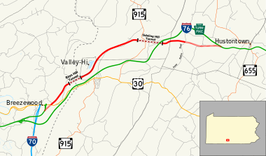
Website
How could so much money and labor go into chiseling holes through the mountains, laying a road bed, only to be walked away from? Twice!
It is a story of greed and revenge.
Two robber barons, whose only goal was to be richer, fought each other with rail lines.
Back in the late 1800's, railroads had a virtual monopoly on transportation, and connecting Philadelphia to Pittsburgh and Ohio was an early goal.
William Vanderbilt who owned the NY Central was angered when George Roberts built the Penn Central Rail Road.
To get revenge, he started the South Penn Rail Road. $16 million and 5 years were allocated, but at the end of 5 years the line was only 40% complete and $10 million had already been spent.
Realizing that it would never make money, one of his major backers, J.P. Morgan, sold his shares to a competing railroad, thus pulling the plug in 1885.
Thousands of workers had labored in the tunnels for $1.25/ 10 hour day, 26 of them lost their lives and the unfinished project became know as Vanderbilt's Folly. (More history)
The South Penn Railroad was abandoned. It sat fallow until it was resurrected to become "The Highway of the Future."
America's First Super Highway, the Pennsylvania Turnpike,
our nation's first limited access toll highway.Opening on October 1, 1940, with hundreds of motorists waiting for days to be the first to ride "The Road of the Future", the Turnpike was an immediate success.
Easy and fast. Nothing to slow you down, (not even a set speed limit at first, and then 70MPH!)
Nothing except the tunnels.
From the start they were bottle necks. The 4 lane traffic funneled to 2 opposing lanes.
Trucks had little clearance. Traffic often backed up for miles.
The Sidling Hill Tunnel had a hard time clearing the fumes.
In the 1960s, four of the tunnels were "twinned" and retrofitted with new lights and tile walls, while 3 were bypassed.
In 1968 the Pennsylvania Turnpike Commission (TPC) bypassed the Ray's and Sidling Hill tunnels and 11 miles of pike.
Then the highway was completely abandoned...again!
This section was used by the TPC to train snow plow drivers, prototype rumble strips, road reflectors, reflective road pant, do vehicle crash, roll over, truck brake distance, and road sign distance visibility tests.
They also stored jersey barriers here. State troopers patrolled the section to stop vandalism. Mostly it just went to seed.
Great Allegheny Passage ( in Maryland)
Directions: 44 minutes from Shawnee
Website
A very long trail!!!
Map image... (Link)
Directions: 44 minutes from Shawnee
Website
A very long trail!!!
Map image... (Link)
Downloadable Map
General Information (see website)
Location and Length
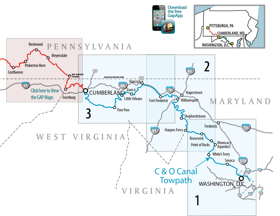
Now complete to Pittsburgh, the 150-mile Great Allegheny Passage connects with the 184.5-mile C&O Canal Towpath at Cumberland, MD to create a 334.5-mile route between Pittsburgh and Washington, DC, free from traffic and motorized vehicles. The Montour Branch will, when completed, connect McKeesport to the Pittsburgh International Airport and Coraopolis.
Trail Grade and Surface
The trail has a packed crushed limestone surface for a smooth ride. Built mainly on abandoned rail beds, the trail is nearly level with the average grade of less than 1%. The steepest eastbound grade - 0.8% - is from Harnedsville to Markleton and Garrett to Deal. The steepest westbound grade is from Cumberland to Deal at 1.75%. Near the Big Savage Tunnel, the trail crosses the Eastern Continental Divide. From that point going east, the trail drops 1,754 feet in 24 miles to reach Cumberland and, going west, it drops 1,664 feet in 126 miles to reach Pittsburgh. View the Elevation Table.
From Cumberland to Washington, DC, you drop 625 feet to sea level on the C&O Canal towpath. The towpath is overall much less improved than the GAP, as it was built for mules and not railroads. Be prepared for ruts, tree roots, mud and mosquitos.
Trail Activities, Horse and other Accessibility
Bicycling and hiking are the two most popular activities. In addition, sections of the trail system are open to equestrians. Horses are permitted only on the grassy areas between Boston & Connellsville; Rockwood & Garrett; Frostburg & State Line. The trail system is universally accessible between dawn & dusk. Winter snow allows cross-country skiing and snow shoeing. Fishermen take the trail to favorite fishing spots. Bird watching is another favorite activity.
Trail Etiquette
Visitors to the trail: Once you leave the trail and enter into the towns, please respect and regard local traffic. Town streets are not bike trails and cyclists are encouraged (by law!) to abide the rules of the road. You are now a "vehicle" and should proceed single file, with traffic. Stop at stop signs. Don't ride on sidewalks. Be considerate when you chain your bike. Treat the town properties as you would want visitors to treat where you live. View Trail Rules.
Average Trail Travel Speed
Walkers and hikers typically average two to three miles an hour; the average cyclists might cover eight to 12 miles an hour. The speed limit on the trail is 15 mph.
Planning Your Trip
In this section, you'll find sample trips of a variety of lengths and suggestions for planning your trip for safety and enjoyment. Please keep in mind that you are in the outdoors and may encounter adverse weather and/or environmental challenges. Planning is essential. Check out Preparation & Checklistbefore setting out.
Trail Towns
Explore the towns along the Great Allegheny Passage!
