Swatara Creek
Check Water Depth here..
Flooding information: Action stage is 7 feet. Flood stage is 9 feet.
Minimum Water Levels: If Harper’s gauge is above 2.25’, water is too high to
launch; if below .3’, water is too low to launch.
Trip info at 0.3 feet water level...
When the water is at 0.3 feet the creek is passable from Hummelstown to Fulling
Mill Road but you will need to get out and walk the kayak at several places. We
have not traveled other sections when the water levels are this low.
Trip info for water level higher than 0.3 feet..
Trip A: From future access to Fulling Mill Road is about 4 hours with lunch
Trip B: From Hummelstown access above rapids to Fulling Mill Road is about
2.75 hours
Trip Info for water level at 1.05 feet
Trip from #9 to #11 ...
3 hours including a half hour lunch ... Notes: Stop for lunch after the 743 bridge ... stoney place to land
Times... from start ... 1/2 hour to Gravel Hill bridge .... from start ... 1.25 hour to 743 bridge
Brochure can be found here.
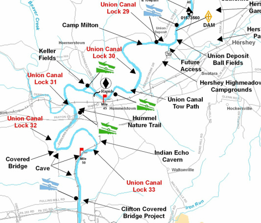
Below is the Water Trail Map for the Middle portion of the Creek
Flooding information: Action stage is 7 feet. Flood stage is 9 feet.
Minimum Water Levels: If Harper’s gauge is above 2.25’, water is too high to
launch; if below .3’, water is too low to launch.
Trip info at 0.3 feet water level...
When the water is at 0.3 feet the creek is passable from Hummelstown to Fulling
Mill Road but you will need to get out and walk the kayak at several places. We
have not traveled other sections when the water levels are this low.
Trip info for water level higher than 0.3 feet..
Trip A: From future access to Fulling Mill Road is about 4 hours with lunch
Trip B: From Hummelstown access above rapids to Fulling Mill Road is about
2.75 hours
Trip Info for water level at 1.05 feet
Trip from #9 to #11 ...
3 hours including a half hour lunch ... Notes: Stop for lunch after the 743 bridge ... stoney place to land
Times... from start ... 1/2 hour to Gravel Hill bridge .... from start ... 1.25 hour to 743 bridge
Brochure can be found here.
Below is the Water Trail Map for the Middle portion of the Creek