Antietam KOA Campground and area attractions
CAMPGROUND INFORMATION (link)
KOA at ANTIETAM
1 hour 18 minutes from New Cumberland
BRING AN INNER TUBE FOR A LAZY FLOAT ALONG CONOCOCHEAGUE CREEK.
The BIG Weekend event for 2017 will be May 5-7 for Hagerstown KOA. Pay for Friday night and pay only a fee of $10.00 for Saturday NIGHT. This fee automatically will benefit the KOA care Camps.
May 5-7, 2017 Cinco De Mayo & KOA Care Camp Weekend
Campground
May 5 - 7, 2017
Annual KOA Care Camp Weekend, pay for Friday night and pay only $10.00 for Saturday night, you MUST CALL for this special deal, no online reservations
Try your luck at the Pinata, make a huge tissue flower of many colors, crafts, margarita glass painting for adults
Check out the Remember When Diner for some Mexican treats!
At this KOA, you can take a lazy canoe ride under a bright canopy of leaves. There's great fishing in the creek too! Meander along winding paths through extensive, lush rock gardens. Relax in the gazebo surrounded by flowers and herbs. Enjoy mini golf, a playground, an outdoor theater, swimming pool and oversized chess and checkers. Participate in themed weekends during the summer. Check out the Haunted House in October, a chilling experience. On weekends, stop by KOA's nostalgic Remember When Diner. Enjoy hamburgers and fries, pizza or a crab cake dinner, as well as a full breakfast menu. Indulge in the soda fountain's old-fashioned malts, shakes and floats. With this KOA as your home base, visit Antietam, Gettysburg and Harpers Ferry battlegrounds. It's a great place for Scouts, church groups and family reunions. Pool: Memorial Weekend - Labor Day Weekend. Max pull thru: 60 feet. Your hosts: the Durham family.
Click here to go to our events page
Amenities ….
Can camp right on the creek …
NOTE ... information for our trip on Antietam Creek is here
______________________________________
Antietam Creek Canoe outfitters
20 minutes away
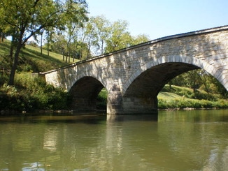
We are On Antietam Creek, at Devil's Backbone Park near Boonsboro Maryland, which is the take out for Antietam's upper section [Funkstown to Our Place/ Devils Backbone Park] and put in for the lower, Antietam Battlefield to The Potomac, section. [that left hand arch in the bridge picture below is the actual put in. It's about 30 feet from our parking area and in our front yard] We are smack in the middle of the 22 miles of Antietam Creek that we service, from Funkstown Maryland to our place(10 mile run) and from our place to the Potomac River (12 mile run). If water levels are above canoeing zero [which they almost always are], we operate the livery Weekends starting April 16 from 10 to dark on an appointment/reservation basis. Call/email in advance for all services and rentals. No call, no email means no guarantee of available boats or shuttles or that I'll be there with the band playing. We tailor each trip just for you. So ... Weekend or not, call in advance Cool Hollow
# 1 301 302 7534 [AM before 9 - PM after 9] or Boonsboro / cell with voice mail [never rely on voice mail] anytime 1-240-447-0444 or better, send an email to schedule your wish.
A TYPICAL ANTIETAM CREEK TRIP [canoe or kayak]
1.PUT IN AND PICK UP TRIP starting at Devil's Backbone [link to all generic trips offered]
A. Arrive at the Put in at Devils Backbone 10:00AM [directions]
B. Sign waivers, unload all the gear you want on the trip, pay fees, make sure your car keys are safe. [run a shuttle if you want your car at the take-out, adds 30 min at start but saves more than 30 min at end]
C. Smart Start Orientation at the put in 10 - 20 min. Longer if requested; shorter if you look bored
D. Put in at about 11AM [Trip can be guided or unguided]
E. Lunch on "two Goose islands" about 12:30
F. Take out at Burnside Bridge, 3PM load boats on the waiting trailer and shuttle; refreshments are on the shuttle during take out and the 15 min trip back to the put-in.
G. Pretty simple for a trip you may never forget.
In general Unguided trips [rentals] including boat, gear and shuttles; on Antietam Creek cost $35-$40 per person. Guided trips with instruction $60-$80 per person. [Link to livery prices detail etc.]
Also, in general, we have discounts for Girl Scouts, Boy Scouts, Church, School, Canoe/Kayak Clubs and similar groups. Inquire, all discounts are discussed and agreed to and invoiced prior to the paddle date.
KOA at ANTIETAM
1 hour 18 minutes from New Cumberland
BRING AN INNER TUBE FOR A LAZY FLOAT ALONG CONOCOCHEAGUE CREEK.
The BIG Weekend event for 2017 will be May 5-7 for Hagerstown KOA. Pay for Friday night and pay only a fee of $10.00 for Saturday NIGHT. This fee automatically will benefit the KOA care Camps.
May 5-7, 2017 Cinco De Mayo & KOA Care Camp Weekend
Campground
May 5 - 7, 2017
Annual KOA Care Camp Weekend, pay for Friday night and pay only $10.00 for Saturday night, you MUST CALL for this special deal, no online reservations
Try your luck at the Pinata, make a huge tissue flower of many colors, crafts, margarita glass painting for adults
Check out the Remember When Diner for some Mexican treats!
At this KOA, you can take a lazy canoe ride under a bright canopy of leaves. There's great fishing in the creek too! Meander along winding paths through extensive, lush rock gardens. Relax in the gazebo surrounded by flowers and herbs. Enjoy mini golf, a playground, an outdoor theater, swimming pool and oversized chess and checkers. Participate in themed weekends during the summer. Check out the Haunted House in October, a chilling experience. On weekends, stop by KOA's nostalgic Remember When Diner. Enjoy hamburgers and fries, pizza or a crab cake dinner, as well as a full breakfast menu. Indulge in the soda fountain's old-fashioned malts, shakes and floats. With this KOA as your home base, visit Antietam, Gettysburg and Harpers Ferry battlegrounds. It's a great place for Scouts, church groups and family reunions. Pool: Memorial Weekend - Labor Day Weekend. Max pull thru: 60 feet. Your hosts: the Durham family.
Click here to go to our events page
Amenities ….
- Wi-Fi Cable TV Pool (5/21 - 9/11) Snack Bar Propane Fishing Mini Golf Firewood Pavilion
- ATM Machine Cable TV Day Trip Planner
Can camp right on the creek …
NOTE ... information for our trip on Antietam Creek is here
______________________________________
Antietam Creek Canoe outfitters
20 minutes away
We are On Antietam Creek, at Devil's Backbone Park near Boonsboro Maryland, which is the take out for Antietam's upper section [Funkstown to Our Place/ Devils Backbone Park] and put in for the lower, Antietam Battlefield to The Potomac, section. [that left hand arch in the bridge picture below is the actual put in. It's about 30 feet from our parking area and in our front yard] We are smack in the middle of the 22 miles of Antietam Creek that we service, from Funkstown Maryland to our place(10 mile run) and from our place to the Potomac River (12 mile run). If water levels are above canoeing zero [which they almost always are], we operate the livery Weekends starting April 16 from 10 to dark on an appointment/reservation basis. Call/email in advance for all services and rentals. No call, no email means no guarantee of available boats or shuttles or that I'll be there with the band playing. We tailor each trip just for you. So ... Weekend or not, call in advance Cool Hollow
# 1 301 302 7534 [AM before 9 - PM after 9] or Boonsboro / cell with voice mail [never rely on voice mail] anytime 1-240-447-0444 or better, send an email to schedule your wish.
A TYPICAL ANTIETAM CREEK TRIP [canoe or kayak]
1.PUT IN AND PICK UP TRIP starting at Devil's Backbone [link to all generic trips offered]
A. Arrive at the Put in at Devils Backbone 10:00AM [directions]
B. Sign waivers, unload all the gear you want on the trip, pay fees, make sure your car keys are safe. [run a shuttle if you want your car at the take-out, adds 30 min at start but saves more than 30 min at end]
C. Smart Start Orientation at the put in 10 - 20 min. Longer if requested; shorter if you look bored
D. Put in at about 11AM [Trip can be guided or unguided]
E. Lunch on "two Goose islands" about 12:30
F. Take out at Burnside Bridge, 3PM load boats on the waiting trailer and shuttle; refreshments are on the shuttle during take out and the 15 min trip back to the put-in.
G. Pretty simple for a trip you may never forget.
In general Unguided trips [rentals] including boat, gear and shuttles; on Antietam Creek cost $35-$40 per person. Guided trips with instruction $60-$80 per person. [Link to livery prices detail etc.]
Also, in general, we have discounts for Girl Scouts, Boy Scouts, Church, School, Canoe/Kayak Clubs and similar groups. Inquire, all discounts are discussed and agreed to and invoiced prior to the paddle date.
NOTE ... information for our trip on Antietam Creek is here
Canoeing and Kayaking Maryland’s Antietam Creekby PENNPADDLER
Burnside's Bridge
Antietam Creek, located in Washington County, is a tributary of the Potomac River and is one of Maryland’s most popular paddling creeks. The West and East Branches of the Antietam Creek are formed near Waynesboro, Pennsylvania but the main canoeable section of the Antietam Creek is near Sharpsburg, Maryland. The creek is separated into the upper and lower sections by a dam at Devil’s Backbone County Park. This content covers the lower section of Antietam Creek beginning at Devil’s Backbone County Park and ending at the Potomac River.
The Antietam is mostly fed by ground water and is canoeable almost year round. Minumum level for the lower Antietam is 2.6 ft, but at this level you will definately be scraping and dragging your boat as our group of kayakers and canoers did during our June 2007 trip. In the future I’ll consider anything below 3.0 ft inadequate for paddling the lower Antietam.
Antietam Creek Water Levels
Antietam Battlefield History
People choose to paddle a location for a variety of reasons such as scenery, serenity, challenge, fishing or even camping. But for some people there might be a different reason to paddle the Antietam Creek. Although it offers the fishing, scenery and some class 1 paddling challenge, what the creek really offers is an opportunity to paddle through the famous Antietam Civil War Battlefield. It was on September, 17 1862 that Union General McClelland launched an attack on General Robert E. Lee along the Antietam Creek near Sharpsburg, Maryland. This battle was the first Civil War Battle fought in northern territory and the most bloody single day battle during the Civil War. During this battle it was the famous event at Burnside’s Bridge where a small number of Confederate soldiers held off thousands of Union soldiers led by General Ambrose Burnside. While paddling the lower Antietam you’ll paddle through a section of the Antietam Battlefield and under the famous Burnside’s Bridge.
The Lower Antietam
The lower section of the Antietam is the most popular section, and for good reason. On this lower section you will experience great scenery, slow sections, fast flowing sections with sharp turns and challenging currents created by a confluence of slow and swift moving water. There are obstacles such as rocks, bridges, riffles, drops, and yes, strainers. These strainers could be a dangerous hazard during high water levels.
Soon after your launch at the Devil’s Backbone County Park your challenge will begin. During low water levels you’ll encounter deceptive current speeds that will make perfect targets of the rocks ahead of you. You’ll also encounter slight drops and staircases of rocks that could stop your boat in one of those awkward swift current situations. You might encounter deceptive current easily capable of casting you overboard. I humbly speak of this from personal experience. And near the end of the trip there is a short class 2 section called Furnace Rapid just before entering the Potomac. Furnace Rapid is not too challenging but takes maneuvering skills during lower water conditions. During higher water conditions you would probably paddle over the rocks. Also during the first few miles of our trip we encountered several fisherman, and one with some attitude. The creek is very narrow in places but do your best to give fisherman as much space as possible.
Warning! – Even though the majority of this creek is class 1 and slow moving in sections, don’t take it lightly. At the launch of our trip one of the locals warned us of the swift current, and his warning was warranted as I dumped my canoe on a few occasions.
Trip Distance and Time
Paddling the lower Antietam is a short trip of approximately 12 miles or less depending on where you take out. Your only launch option is at Devil’s Backbone County Park on Route 68 near Sharpsburg, but you can choose between two takeouts. The first takeout is the Burnside Bridge takeout just below the actual historical Burnside Bridge. (Warning! It is illegal to dock at the actual Historical Burnside Bridge in the Antietam Battlefield). The other option, which I recommend, is the Potomac River takeout. Paddling from Devil’s Backbone to the Potomac can take four to six hours depending on your ambition. It took us four hours and we didn’t work hard. Althought there are some very slow spots in sections, the majority of time the current seemed to carry us along at a decent three to four miles per hour. Shuttling vehicles isn’t bad either. It should take about an hour. During your shuttle you can drive down the Sharpsburg Pike (Route 65) to the Harpers Ferry Road, or you can drive through the country on Wheeler Road and Route 34. Here is a link to an Antietam Creek map.
NOTE ... information for our trip on Antietam Creek is here
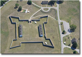
Fort Frederick State Park 17 minutes to the west of KOA
Fort Frederick State Park serves as the headquarters for a complex of facilities that includes:
American history from the colonial period to the present can be discovered at Fort Frederick State Park. Features include:
Fort Frederick
Fort Frederick State Park serves as the headquarters for a complex of facilities that includes:
- Fort Frederick State Park
- Western Maryland Rail Trail
- Woodmont Natural Resources Management Area
American history from the colonial period to the present can be discovered at Fort Frederick State Park. Features include:
- Our 585 acre park features a unique stone fort that served as Maryland’s frontier defense during the French and Indian War.
- The Fort's stone wall and two barracks have been restored to their 1758 appearance.
- Historic exhibits are in the Fort, barracks, CCC Museum and Visitor Center.
- The park borders the Potomac River.
- The Chesapeake and Ohio Canal passes through the park.
- The park also features a boat launch, campsites, camp store, fishing, flat water canoeing, a hiking trail, interpretive and educational programs, picnicking, a playground, and a shelter.
- For more information on facilities, hours, and programs please contact the visitor center.
- Download the 2017 Calendar of Events
Fort Frederick
- The stone fort built in 1756 protected Maryland’s frontier settlers during the French and Indian War.
- Fort Frederick is unique because of its strong stone wall, large size, and roomy barracks.
- The fort saw service during the American Revolution as a prison for British soldiers.
- During the Civil War, Union troops were often stationed near the fort to guard the C & O Canal.
- In 1922, the State of Maryland acquired the fort and in 1930's, the Civilian Conservation Corps restored the fort walls and began development of the state park.
- The fort barracks are open seven days a week from Memorial Day to Labor Day and on the weekends in the spring and fall.
- During those times, staff and volunteers dressed in 18th century clothing occupy the fort, demonstrating daily life in the 18th century.
- Group Tours are available seasonally. Call 301-842-2155 for details.
- Learn more about the Fort's history
- Take a Virtual Tour of Fort Frederick State Park by downloading a Powerpoint presentation
- Learn about Fort Frederick in the Civil War

Western Maryland Rail trail
Beginning approximately one-half mile west of historic Fort Frederick State Park in Big Pool, Maryland, the Western Maryland Rail Trail (WMRT) winds along the Potomac River through rolling farmland, woodlands, and rural towns to its terminus at the southern slope of Sideling Hill Ridge. In August of 1990, the Maryland Department of Natural Resources acquired 20.3 miles of the abandoned segment of the Western Maryland Railroad Line, and the three lots in the Town of Hancock from CSX Transportation, Inc. The rail corridor was purchased with state-wide DNR Program Open Space funding at a cost of $1,042,000.
The WMRT follows a path rich in history. The Potomac River valley has been an important transportation corridor for hundreds of years. From the Native Americans to the National Road to the C&O Canal, people have always traveled the path of the Potomac River. The Western Maryland Railway was no exception. In its heyday, the Western Maryland Railway was a lifeline to the tri-state area of Maryland, Pennsylvania, and West Virginia. Through the construction of the WMRT on this abandoned railroad bed, numerous opportunities are now available to visit old ruins of days past. There are interpretive signs along the length of the trail at many of these locations.
The WMRT currently offers about 23 miles of flat, paved trail surface. The eastern terminus of the trail, known as Big Pool Station, is located ½ mile west of historic Fort Frederick State Park in Washington County, Maryland. Many visitors begin their WMRT excursions here although some prefer to start at the western terminus located in Pearre, Maryland, near Sideling Hill Wildlife Management Area. The WMRT parallels the C&O Canal for its entire length.
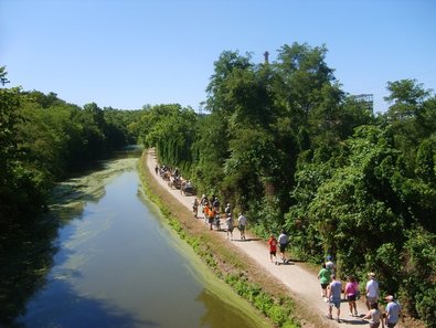
C & O Canal close by access at Williamsport Visitors center … 9 minutes away
Through community events, partnerships and interpretive programs, the Chesapeake and Ohio Canal National Historical Park expands the meaning of the park to new audiences, providing an opportunity for communities and park visitors to learn more about their heritage.
Three years ago, nine communities along the C&O Canal formed the Canal Towns Partnership, an economic development initiative with the goal of cooperatively marketing and making improvements, such as the addition of bike lanes and bike racks, to attract visitors into the canal's gateway communities. In 2012, the Chesapeake and Ohio Canal National Historical Park, in partnership with the Canal Towns Partnership installed a series of waysides and hosted events to increase visitor knowledge of the unique towns located along the canal and their local and canal heritage. Additionally, the Canal Towns Partnership is working with the park to support park visitors, providing the resources needed as visitors travel the C&O Canal Towpath from town to town. The Canal Town Partnership has not only strengthened the relationships between the park and adjacent towns, but also improved the communications between the towns.
With nearly 200 miles of towpath, the C&O Canal is the backbone of dozens of communities along the Potomac River. Events to connect these communities with local heritage occur each year and include unique opportunities such as the Hancock Bluegrass Events - featuring local musicians playing bluegrass tunes along the canal and telling stories of the community and canal operations long ago.
Tradition is vital to communities and local heritage, and the C&O Canal has played a vital role in each community along the 184.5 mile canal for many years prior to becoming a park. Local communities have enjoyed canal tour boat excursions intermittently along the C&O Canal for nearly 70 years. Additionally, the park features Canal Family Reunions each summer in numerous towns along the towpath. These events feature guest speakers from the local community to share their stories and connection to the C&O Canal. From children's fishing rodeos are held annually in watered sections of the canal to the newly opened Visitor Center at Ferry Hill featuring living history programs, special events enable local communities to connect with their heritage along the C&O Canal.
CONTACT THE PARK
Mailing Address:
1850 Dual Highway, Suite 100
Hagerstown, MD 21740
Phone:
(301) 739-4200
This phone number is answered Monday-Friday from 8am-4pm.
Contact Us
TOOLS
