Conodoguinet Creek
Check Water Depth here..
Flooding Information: Action stage is 6 feet. Flood stage is 8 feet.
Minimum Water Levels: should be over 1.7 feet for good navigation on creek ..
not sure if this is true for all portions.
Trip Info for 2 foot height (May 25)
Trip 1: From Willow Mill Park (4) to Good Hope Access (7)....
Travel time ..Total time was 4 hours with no lunch break … Point 4 to the Bridge
written in on map was 2 hours .. This bridge to point 5 was 0.45 hours… Point 5
to 581 bridge was 0.5 hours … 581 bridge to point 7 was 0.75 hours
Important note: We could not find a usable takeout at location 6.
Brochure can be found here.
Additional Brochure can be found here.
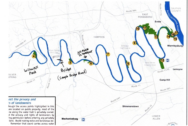
Map (with extra labels) of Condoquinet Creek from Willow Mill Park to
Susquehanna River is below
Susquehanna River is below
Access Point Miles to Next Access Point Coordinates
B1 Creekview Park 3.2 40.2386, -77.1913
B2 Letort Falls Park 4.6 40.2375, -77.1409
B3 Scott Farm Work Center/App. Trail 5.5 40.2604, -77.1045
B4 Willow Mill Park 6.5 40.2578, -77.0426
B5 Hidden Creek Park 1.2 40.2533, -77.0099
B6 Westover Commons Area 1.9 40.2526, -76.9912
B7 Good Hope Access 3.7 40.2588, -76.9758
B8 Conodoguinet Youth Park 4.1 40.2523, -76.9577
B9 Acri Meadow Park 0.8 40.2665, -76.9518
B10 Oyster Mill Park 0.3 40.2763, -76.9489
B11 Adams-Ricci Community Park 1.8 40.2766, -76.9427
B12 Siebert Park 1.4 40.2544, -76.9269
B13 Pine Hill Arboretum 1.0 40.2703, -76.9323
B14 Ridley Park 0.3 40.2706, -76.9213
B15 Rupley Park 0.1 40.2689, -76.9151
B16 West Fairview Park 0.1 40.2720, -76.9172
B17 West Fairview Point Take-Out Only 40.2732, -76.9140
